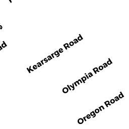
33 KEARSARGE ROAD
Owner Information
HALL ELAINE D
33 KEARSARGE RD
MARSHFIELD, MA 02050


Property Details
33 KEARSARGE ROAD is classified as a Single Family Residential (Old style).
The primary structure on this property was built in 1922. There are 1,099ft2 of built area within this property. There is 1,099ft2 of residential/living space within this property. This property is listed as having 7 rooms.
33 KEARSARGE ROAD is valued at $481,300. The land is valued at $367,400 and the structures are valued at $113,000. There is an additional valuation of $900 on this property.
This property is in Zone R-3. Confirm with local Zoning Board authorities to ensure there are no overlays or other easements on this property.
33 KEARSARGE ROAD was last sold on Friday, May 1, 2015 for $1.
Assessment data from fiscal year 2022.
Flood Data
This property is completely within the AO Zone (shallow flooding, up to 3 feet).
This information is sourced from the FEMA National Flood Hazard Layer. See our full disclamer.
Broadband Internet Providers
| Provider | Type | Bandwidth (mbps) | |
|---|---|---|---|
| T-Mobile | Fixed Wireless | 25 | 3 |
| Verizon New England Inc. | Fiber | 940 | 880 |
| Viasat Inc | Satellite | 100 | 3 |
| VSAT Systems, LLC. | Satellite | 2 | 1 |
| HughesNet | Satellite | 25 | 3 |
| GCI Communication Corp. | Satellite | 0 | 0 |
| Comcast | Cable | 1000 | 35 |
Broadband service provider data from December 2020.
Adjacent Properties
- 37 KEARSARGE ROAD
Single Family Residential owned by OKEEFE PATRICK J TR - 30 OLYMPIA ROAD
Single Family Residential owned by GREGORY PETER & CAROL TRUSTEES - 34 OLYMPIA ROAD
Single Family Residential owned by MURRAY MICHAEL J - 40 OLYMPIA ROAD
Single Family Residential owned by SACCO JOSEPH W JR ETAL - 25 KEARSARGE ROAD
Multiple Houses on one parcel owned by KING RUTH M